AREA 18 - SNAKE VALLEYUpdated: June 2, 2023Recent changes and additions in red text |
|
|
MANAGEMENT No Proposed Determination of Water Rights books have been published for this area, nor are there are any state-administered distribution systems. Click here to see statistics for this area. Click here to see a list of Utah water rights in Snake Valley which are junior to SNWA filings. SOURCES Surface Water - Surface waters are open to appropriation if unappropriated sources with adequate supply and quality can be found. Most known sources of useable size have been appropriated. Ground Water - The State Engineer is of the opinion that water is available for development in the Snake Valley. As future water development occurs, water available for future appropriation under new applications will be re-evaluated. Applicants are allowed to appropriate a limited amount of water up to the amount of water needed for: the irrigation of 136 acres (which is the acreage irrigated by a full pivot with end gun, 544 acre-feet); year-round domestic requirements of 1.0 equivalent domestic unit (0.45 acre-foot); and the stockwatering of 200 head of livestock (in cattle or horses or equivalent species, 5.6 acre-feet). However, in an effort to protect the resource from over development, and to provide for an orderly and carefully monitored development of the water resource while carefully reviewing each application for speculation or monopoly in the Snake Valley area, applicants, their successors, or related entities will be limited to the quantities stated above which must be placed to beneficial use and certificated before any subsequent application can be approved. Resultantly, in order to protect the integrity of the priority system, subsequent applications will be rejected as opposed to being held pending certification of a prior application. Each new application will be evaluated based on its own merits and when seemingly un-related entities seek new appropriations neighboring already approved, unperfected appropriations where monopolization of the resource is possible, approval will be granted at the discretion of the State Engineer. GENERAL Applications are advertised in the Tooele Transcript, Millard County Chronicle, or the Nephi Times-News. Filings that may involve the diversion of water in Utah for use in Nevada (export) would be subject to the special criteria the statutes require for such projects. The general irrigation diversion duty for this area, which the State Engineer uses for evaluation purposes, is 4.0 acre-feet per acre per year. The consumptive use requirement is determined from the publication Consumptive Use of Irrigated Crops in Utah, Research Report 145, Utah State University, 1994, unless the applicant submits other data for consideration. This area is administered by the Weber River Regional Office in Salt Lake City. Other requirements The Water Right applicant is strongly cautioned that other permits may be required before any physical development of a project can begin and it is the responsibility of the applicant to determine the applicability of and acquisition of such permits. In order to avoid delays and ensure that Water Right approvals conform to applicable local ordinances, applicants should contact local governmental entities in advance to determine what ordinances are in place that affect the proposed project and to make sure that Water Right filings conform to those ordinances. The approval of a Water Right application does not imply any approval of a project by any other governmental entity. Approval of the project proposed in the Water Right application should be obtained from local governmental entities as necessary to implement a project. REFERENCES Technical Publication No. 14, Water-Resources Appraisal of the Snake Valley Area, Utah and Nevada; Utah State Engineer; 1965. Technical Publication No. 56, Hydrologic Reconnaissance of the Tule Valley Drainage Area, Juab and Millard Counties, Utah; Utah Department of Natural Resources; 1977. Technical Publication No. 59, Hydrologic Reconnaissance of the Fish Springs Flat Area, Tooele, Juab, and Millard Counties, Utah; Utah Department of Natural Resources; 1978. Technical Publication No. 71, Hydrologic Reconnaissance of the Southern Great Salt Lake Desert and a Summary of the Hydrology of West-Central Utah; Utah Department of Natural Resources; 1981. Basic Data Report No. 43, Selected Test-Well Data from the MX-Missile Siting Study, Tooele, Juab, Millard, Beaver, and Iron Counties, Utah; Utah Department of Natural Resources; 1985. Water-Resources Investigative Report 95-4173 , Simulated Effects of Proposed Ground-Water Pumping in 17 Basins in East-Central and Southern Nevada; U.S. Geological Survey; 1995 Scientific Investigations Report 2007-5261, Water Resources of the Basin and Range Carbonate-Rock Aquifer System, White Pine County, Nevada, and Adjacent Areas in Nevada and Utah; U.S. Geological Survey; 2007 USGS Scientific Investigations Report 2014-5103, Hydrology and Numerical Simulation of Groundwater Movement and Heat Transport; 2014. USGS Scientific Investigations Report 2014-5213, Steady-State Numerical Groundwater Flow Model of the Great Basin Carbonate and Alluvial Aquifer System; 2014. USGS Scientific Investigations Report 2017-5072, Groundwater Model of the Great Basin Carbonate and Alluvial Aquifer System Version 3.0: Incorporating Revisions in Southwestern Utah and East Central Nevada; 2017. MODELING Regional Ground-Water Flow, Carbonate-Rock Province, Nevada, Utah, and Adjacent States; USGS Open-File Reports 93-170 and 93-420 ; 1993. PREVIOUS PAGE UPDATES |

Policy area in green,
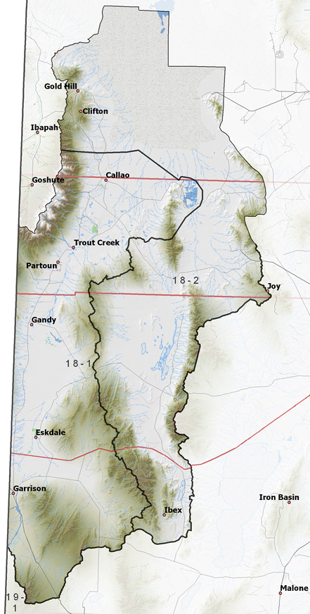
click on the map for more detail DESCRIPTION Ranging from western Tooele County through western Juab County and into northwestern Millard County (T5S to T25S), this area covers a portion of the Great Salt Lake Desert and several relatively dry valleys. This area is bounded on the north by the Great Salt Lake Desert, on the east by Dugway Valley and the Sevier River drainage, on the west by the Deep Creek Mountains and Nevada, and on the south by Wah Wah and Pine Valleys. The highest point in the area is 12,087 foot Ibapah Peak, while the lowest is the shore of the Great Salt Lake at about 4,225 feet, giving a total relief of about 7,860 feet. |
|
|
|