AREA 09 - SAN JUAN RIVERUpdated:ĀApril 2, 2011 |
|
|
MANAGEMENT No Proposed Determination of Water Rights books have been compiled or published for this area. There are court decrees in this area covering the waters of Spring, North Fork South Fork, Verdure and Montezuma Creeks. There is one state-administered distribution system in this area, the Blue Mountain Distribution System that is administered by the Blue Mountain Commissioner and primarily includes South Fork Creek. Because this area is part of the Colorado River basin, the conditions of the 1922 Colorado River Compact, the 1944 Mexican Treaty, the 1948 Upper Colorado River Compact, and the State Engineer's Colorado River Policy apply. There are two federal reserved water right settlement agreements in this area. In 2000, an agreement was made covering the water rights for Hovenweep National Monument. A similar agreement was signed in 2002 concerning Rainbow Bridge National Monument. Negotiations for federal reserved water rights on Native American Indian reservations are ongoing. Click here to see statistics for this area. SOURCES Surface and Ground Water: The water resources of this area are considered to be limited. New appropriations are limited to small amounts of beneficial use sufficient to serve the domestic requirements of one family, the irrigation of one acre, and ten head of livestock (or equivalent livestock units). New diversions and consumptive uses that require more water than this must be accomplished by filing a change application on valid existing water rights owned or acquired by the applicant. However, some water is available for larger appropriations on a Temporary (one-year) or Fixed Time period basis. Non-consumptive uses such as hydroelectric power generation would be considered on the individual merits of each application.
All applications, including changes on existing water rights, are considered on their individual merits, with emphasis on their potential to interfere with existing rights and to ensure that there is no enlargement of the underlying rights. Applications are generally approved upon showing of an immediate need for water and with the presumptions that the applicant has all necessary resources and authorities to diligently develop the proposed beneficial uses of water and to file proof. Proof must be submitted by a registered land surveyor or engineer licensed in the State of Utah. Requests for extensions of time in which to submit proof will be critically reviewed after the initial five-year period. GROUNDWATER MANAGEMENT PLAN Because the State Engineer believes there are potential human health concerns, a Ground-water Management Policy for the Monticello Mill Tailings Site and Adjacent Areas which sets conditions for appropriating and changing ground water in the Monticello area has been issued and is effective as of May 21, 1999GENERAL Applications are advertised in the San Juan Record in Monticello or The Times-Independent in Moab depending on the county where the source is located. At the discretion of the Regional Engineer, an application may be advertised in more than one county, if he determines the application could affect the water rights located in bordering counties. Filings that may involve the diversion of water in Utah for use in Arizona or Colorado (export) would be subject to the special criteria the statutes require for such projects. The general irrigation diversion duty for this area, which the State Engineer uses for evaluation purposes, is 4.0 acre-feet per acre per year. Click here to see a duty map for this area. The consumptive use requirement is determined from the publication Consumptive Use of Irrigated Crops in Utah, Research Report 145, Utah State University, 1994, unless the applicant submits other data for consideration. This area is administered by the Southeastern Regional Office in Price. Other Requirements The Water Right applicant is strongly cautioned that other permits may be required before any physical development of a project can begin and it is the responsibility of the applicant to determine the applicability of and acquisition of such permits. In order to avoid delays and ensure that Water Right approvals conform to applicable local ordinances, applicants should contact local governmental entities in advance to determine what ordinances are in place that affect the proposed project and to make sure that Water Right filings conform to those ordinances. The approval of a Water Right application does not imply any approval of a project by any other governmental entity. Approval of the project proposed in the Water Right application should be obtained from local governmental entities as necessary to implement a project. REFERENCES Technical Publication No. 15, Water from Bedrock in the Colorado Plateau of Utah; Utah State Engineer; 1966. Technical Publication No. 84, Ground-water Conditions in the Lake Powell Area, Utah; Utah Department of Natural Resources; 1986. Technical Publication No. 86, Bedrock Aquifers of Eastern San Juan County, Utah; Utah Department of Natural Resources; 1986. Technical Publication No. 94, The Base of Moderately Saline Water in San Juan County, Utah; Utah Department of Natural Resources; 1990. Special Study 120, The Hydrogeology of MOAB-SPANISH VALLEY, Grand and San Juan Counties, Utah, with Emphasis on Maps for Water-Resource Management and Land-Use Planning; Utah Geological Survey; 2007. MODELING Four Corners Area, Mesozoic Rocks Ground-water Flow Model, 1988. PREVIOUS PAGE UPDATES |
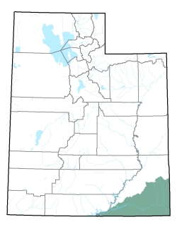
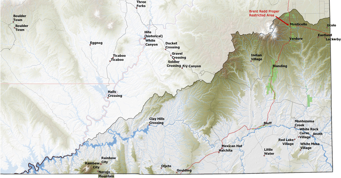
Policy area in green,
click on the map for more detail DESCRIPTION Located in the southeastern corner of the state in San Juan County, this area extends from T32S to the Arizona state line at T43S. The major stream in this area is the San Juan River, which marks the northern boundary of the Navajo Indian Reservation and runs westward into Lake Powell. The Abajo (Blue) Mountains give rise to Spring Creek, North Fork Creek, South Fork Creek, Verdure Creek, and Montezuma Creek, which flow eastward toward the Monticello area, and Johnson Creek and Recapture Creek which drains the Blanding area. This area is bordered on the north and west by the Colorado River and the Kane Springs Creek drainage, on the east by Colorado, and on the south by Arizona. The highest point in the area is 11,360 foot Abajo Peak in the Abajo Mountains, while the lowest is the Colorado River at the Arizona-Utah line at about 3,200 feet, giving a total relief of about 8,160 feet. |
|
|
|