 ESCALANTE RIVER -
AREA 97 ESCALANTE RIVER -
AREA 97
ESCALANTE RIVER -
AREA 97 ESCALANTE RIVER -
AREA 97 Original Posting: April 2, 2002
Updated: December 10, 2008
DESCRIPTION:
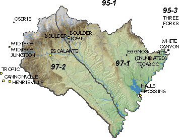
Extending from T30S in the north to T42S in the south, this area is located
in eastern Garfield and northeastern Kane Counties. It encompasses the drainage
of the Escalante River and a number of intermittent streams which empty into
Lake Powell. It is bounded on the west by the Sevier River and on the east by
Lake Powell. On the north is the Dirty Devil River basin and on the south is
the Kaiparowits Plateau. The highest point is at about 11,300 feet, on Boulder
Mountain, while the lowest point is at the shore of Lake Powell at 3,700 feet,
giving the basin a total relief of about 7,600 feet. Click
here to see a map of the area.
MANAGEMENT:
There are three court decrees in this area covering surface water: the Boulder
Creek Decree, the Escalante
River Decree, and the Deer
Creek Decree. Water rights in this area were compiled into three Proposed
Determinations of Water Rights. The Boulder
area book was compiled in 1967, while the Escalante and supplemental books
were done in 1969. A pre-trial order was issued for the Boulder book in 1975
and for the remaining
books in 1977. Because this area is tributary to the Colorado River, the
provisions of the 1922 Colorado River Compact, the 1944 Mexican Treaty, and
the 1948 Upper Colorado River Basin Compact and the State Engineer's Colorado
River Policy and the State
Engineer's Colorado River Policy apply. There are no state-administered
water distribution systems in this area. Click
here to see statistics for this area.
SOURCES:
SURFACE AND GROUND WATER - Surface waters, except for isolated sources, and
ground waters with a direct connection thereto, are considered to be fully appropriated.
New diversions and uses involving surface waters must be accomplished by change
applications based on valid existing water rights. Fixed-time projects involving
surface waters must be accomplished by temporary change applications on valid
existing water rights, which require annual renewal. Change applications proposing
a change from surface to underground sources, or vice versa, will be critically
reviewed to assure hydrologic connection, that there are no enlargements of
the underlying right(s), and that there will be no impairment of other rights.
The State Engineer believes there is some unappropriated water available in
the aquifer system and in isolated surface sources. In this area, domestic filings,
limited to the requirements of one family, the irrigation of 1/4 acre, the watering
of 10 heads of livestock (1.73 acre-feet), or an equivalent amount for other
uses, are individually reviewed for potential interference with existing rights,
and some have been approved. The State Engineer issued
a letter on Dec. 10, 2008 to Escalante River Water Users regarding changes
from previous policy.
Applications are generally approved upon a showing of immediate need for water and with the presumptions that the applicant has all the necessary resources and authorities to diligently develop the proposed beneficial use of water and to file proof. Typically, a period of five years is allowed for full development with extensions of time granted only under unique circumstances clearly beyond the control of the applicant.
GENERAL:
Applications are advertised in the Garfield County News and the Southern Utah
News, dependent upon the county in which the water is to be diverted. The general
irrigation diversion duty for this area, which the State Engineer uses for evaluation
purposes, is 4.0 acre-feet per acre per year. The consumptive use requirement
is determined from the publication Consumptive
Use of Irrigated Crops in Utah, Research Report 145, Utah State University,
1994, unless the applicant submits other data for consideration. This area is
administered by the Southwest Regional Office in Cedar City.
Other Requirements
The Water Right applicant is strongly cautioned that other permits may be required before any physical development of a project can begin and it is the responsibility of the applicant to determine the applicability of and acquisition of such permits. In order to avoid delays and ensure that Water Right approvals conform to applicable local ordinances, applicants should contact local governmental entities in advance to determine what ordinances are in place that affect the proposed project and to make sure that Water Right filings conform to those ordinances. The approval of a Water Right application does not imply any approval of a project by any other governmental entity. Approval of the project proposed in the Water Right application should be obtained from local governmental entities as necessary to implement a project.
REFERENCES:
Technical
Publication No. 15; Water from Bedrock in the Colorado Plateau of Utah;
Utah State Engineer; 1966.
Technical Publication No. 81; Groundwater Conditions in the Kaiparowits Plateau Area, Utah and Arizona, with Emphasis on the Navajo Sandstone; Utah Depart of Natural Resources; 1986.
Technical Publication No. 84; Groundwater Conditions in the Lake Powell Area, Utah; Utah Department of Natural Resources; 1986.
Basic Data Report No. 41; Selected Hydrologic Data, Kolob-Alton- Kaiparowits Coal Fields Area, South-Central Utah; Utah Department of Natural Resources; 1983.
MODELING: None.
PUBLIC COMMENTS:ĀScanned Documents
PREVIOUS PAGE VERSIONS: April 2, 2002