AREA 01 - WESTERN MOAB VICINITYUpdated: July 9, 2019
|
|
|
MANAGEMENT A Proposed Determination of Water Rights was published in 1993 (01-1-Northwest Colorado River); an Interlocutory Decree was issued in 1995. The only other decree in this area is the 1938 West Water Creek Decree. There is no state-administered distribution system in this area. Because this area is part of the Colorado River basin, the conditions of the 1922 Colorado River Compact, the 1944 Mexican Treaty and the 1948 Upper Colorado River Compact and the State Engineer's Colorado River Policy apply. Click here to see statistics for this area. SOURCES SURFACE & GROUND WATER: The water resources of this area are considered to be limited. New appropriations are limited to small amounts of beneficial use sufficient to serve the domestic requirements of one family, the irrigation of one acre, and ten head of livestock (or equivalent livestock units). New diversions and consumptive uses that require more water than this must be accomplished by filing a change application on valid existing water rights owned or acquired by the applicant. However, some water is available for larger appropriations on a Temporary (one-year) or Fixed Time period basis. Non-consumptive uses such as hydroelectric power generation would be considered on the individual merits of each application. All applications, including changes on existing water rights, are considered on their individual merits, with emphasis on their potential to interfere with existing rights and to ensure that there is no enlargement of the underlying rights. Applications are generally approved upon showing of an immediate need for water and with the presumptions that the applicant has all necessary resources and authorities to diligently develop the proposed beneficial uses of water and to file proof. Proof must be submitted by a registered land surveyor or engineer licensed in the State of Utah. Requests for extensions of time in which to submit proof will be critically reviewed after the initial five-year period. ARCHES PROTECTION ZONE: On May 22, 2015, the State of Utah entered into an agreement with the United States of America for a federal reserved water right for Arches National Park. As a part of the agreement, a Protection Zone was established to protect the flow of perennial, intermittent, and ephemeral streams, seeps, springs and other naturally-occurring water within the Park whose source is surface water or groundwater from the Entrada aquifer. This Protection Zone was adopted as policy for Water Right Area 01 on October 26, 2015. The adopted policy document and map of the Protection Zone area are found here. For purposes of the agreement and this policy, the “Entrada aquifer” is defined as the Slick Rock Member of the Entrada Sandstone, the Moab Member of the Curtis Formation, and all other rock units lying above the Moab Member of the Curtis Formation to and including the ground surface. Geologic units below the Entrada aquifer are not included in the Protection Zone. The Protection Zone is comprised of the area outside the Park boundaries within that portion of the drainage basins of Courthouse Wash and Sevenmile Canyon lying north and east of the Moab Fault or the Moab Splay Fault and the area outside the Park boundaries within that part of the drainage basin of Salt Wash lying south of the Township 22 South and Township 23 South dividing line, and lying within Sections 33, 34 and 35 of Township 22 South, Range 20 East, SLB&M. The State Engineer will not approve:
On July 8th, 2019 the State Engineer clarified this policy to confirm that the Arches Protection Zone includes well locations where there is a hydrologic connection to the Entrada aquifer. Underlying geologic units may not in some cases be isolated from the Entrada Formation and pumping from these units could result in water being withdrawn or drawn down from the Entrada aquifer. Such an appropriation of water or that portion of water being withdrawn or drawn down from the Entrada aquifer would constitute an appropriation from the Protection Zone and is not allowable under this policy. Any applications seeking to withdraw water from geologic units found below the Entrada aquifer must submit with their application sufficient scientific data showing that withdrawal of water from those units does not impact the flow of perennial, intermittent, and ephemeral streams, seeps, springs and other naturally-occurring water within Arches National Park whose source is surface water or groundwater from the Entrada aquifer. At a minimum evidence sufficient to make such a showing would likely include analysis of drill hole cuttings by a professionally licensed geologist, or scientific agency such as the Utah Geological Survey or Untied States Geological Survey to verify the target aquifer lies below the Entrada aquifer. Scientific data is also required to show that no hydrologic connection exists between the Entrada aquifer and the target well. Such evidence may take the form of pump tests from the target aquifer with associated monitoring wells in the Entrada aquifer to verify no hydrologic connection exists between the two. Chemical testing of the waters in the separate aquifers as well as static head pressures between the two aquifers would also provide information on the relative connectedness or lack thereof between the two aquifers. Where conditions are similar, testing which has already occurred and is on the record may be substituted for new testing. Summary and presentation of such evidence is best submitted to the State Engineer in report form as part of an application requesting a point of diversion in the protected area. An interactive map of the Protection Zone can be found here. GENERAL Applications are advertised inThe Times-Independent in Moab or the San Juan Record in Monticello depending on the county where the source is located. At the discretion of the Regional Engineer, an application may be advertised in more than one county, if he determines the application could affect the water rights located in bordering counties. Filings that may involve the diversion of water in Utah for use in Colorado (export) would be subject to the special criteria the statutes require for such projects. The general irrigation diversion duty for this area, which the State Engineer uses for evaluation purposes ranges from 4.0 to 6.0 acre-feet per acre per year. Click here to see a duty map for this area. The consumptive use requirement is determined from the publication Consumptive Use of Irrigated Crops in Utah, Research Report 145, Utah State University, 1994, unless the applicant submits other data for consideration. This area is administered by the Southeastern Regional Office in Price. Other Requirements The Water Right applicant is strongly cautioned that other permits may be required before any physical development of a project can begin and it is the responsibility of the applicant to determine the applicability of and acquisition of such permits. In order to avoid delays and ensure that Water Right approvals conform to applicable local ordinances, applicants should contact local governmental entities in advance to determine what ordinances are in place that affect the proposed project and to make sure that Water Right filings conform to those ordinances. The approval of a Water Right application does not imply any approval of a project by any other governmental entity. Approval of the project proposed in the Water Right application should be obtained from local governmental entities as necessary to implement a project. REFERENCES Technical Publication No. 15, Water from Bedrock in the Colorado Plateau of Utah; Utah State Engineer; 1966. MODELING None PREVIOUS PAGE UPDATES |
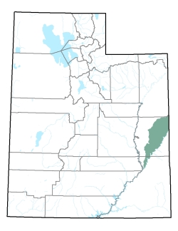
Policy area in green,
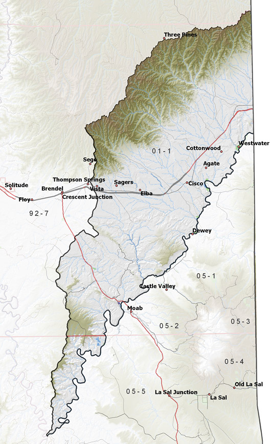
click on the map for more detail DESCRIPTION Located along the western side of the Colorado River from its point of entry into Utah to its confluence with the Green River, this area extends through Grand County into San Juan County from T15S to T30S. It is bordered on the north by the Book Cliffs, on the east by Colorado, on the south and southeast by the Colorado River, and on the west by the Green River drainage. The highest point in the area is the 9,450 foot Nutter’s Peak in the Book Cliffs, while the lowest is the confluence with the Green River at about 3,780 feet, giving a total relief of about 5,670 feet. |
|
|
|